
Custom Museum and Gallery City Map Illustrations

Lively lettering and tactile textures combine in my Manchester city map illustration, capturing key locations like the Whitworth Gallery, the People’s History Museum, and the Northern Quarter . Even with the typical Manchester rain, the map adds a splash of colour with rainbows.
Bringing Museums to Life in Glasgow and Manchester
In this project, I created custom museum and gallery city map illustrations at the heart of the Museums Association Annual Conference's visual identity. These maps needed to paint characterful pictures - of Glasgow and Manchester - but they also needed to invite the eye to explore every corner; capturing the buzz of the full and diverse program, unfolding all over town. I used bright colours, busy lettering, and lively textures to start building a whole world of detail. The primary job was creating the cover for the conference guide, featuring the museum and gallery city map illustrations as the focal point.

Cropped Detail of Manchester Map
Featuring local legends Bez dancing and Coronation Street’s Bet Lynch, in the vibrant area between Chinatown and Canal Street. These maps are a way to celebrate the city’s personality, layering in cultural references, visual texture, and the kind of details that locals get.
Electrifying Victorian Facades
I also wanted to shine a bright light on the hidden excitement within each museum site and used kaleidoscopic colour and clashing texture to make even the most solemn Victorian facade go electric.
Peer closer still, and you'll discover a bustling community of tiny people, and local tales interwoven into the map's design (see if you can spot the little L.S.Lowry figures within the Manchester art!). Attendees could uncover these details as they explored the artwork. It felt like the perfect analogy for the themes of experiential learning and exploration… topics always on the agenda at a Museums Conference.

This detailed Glasgow map illustration captures the city’s rich museums, galleries and cultural hubs. Featuring key venues like the Kelvingrove Art Gallery and Riverside Museum, the map highlights event hotspots and guides attendees through Glasgow’s rich cultural landscape.
Beyond the Cover
Beyond guiding attendees, the illustrations appeared across event materials: banners, invitations, and presentations - to create a cohesive visual identity. Below are two examples where elements from the main map were re-collaged into new layouts. With tactile print textures and electric palettes, they drew viewers in, invited closer attention, and gave the conference a bold, distinct look.
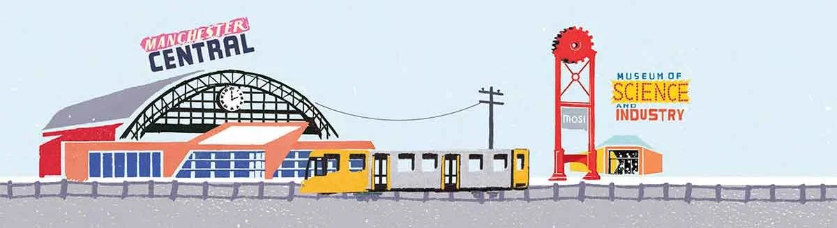
Key landmarks from the illustrated map, including Manchester Central and the Museum of Science and Industry, reassembled into a fresh composition. This modular approach allowed the design team to extend the visual language across formats with consistency and impact.

Reconfigured from individual map elements, this collage draws together key visual motifs, Chinatown, City Hall, figures, and a rainbow, into a new composition. These recombinations helped build a bold, flexible identity across print and digital assets.
Engagement through Visual Storytelling
As the conference unfolded, the illustrations did more than decorate—they engaged. They turned facts and figures into visually memorable moments, making complex information more accessible and memorable.

Cropped Detail of Glasgow Map
Showing the Glasgow Museum of Art and the legendary Duke of Wellington statue- continuously improved by locals with the addition of traffic cones. Maps like this let me bring out the character of a city through small details, local quirks, and researched cultural references.
Maps with a Life of Their Own
Witnessing the map's impact on engagement was really rewarding. The illustrations played a pivotal role in fostering social media interaction, as attendees shared their conference experiences online, prompted by the vibrant visuals.
The maps seemed to take on a life of their own, connecting with the audience and enriching the event experience.
Are you ready to transform your event into an unforgettable visual experience?
I’ve put together a page showing how these projects were used in publications and how they look in print here. Or, if you’d like to discuss custom museums and gallery city map illustrations, feel free to get in touch below!