Map Illustration Services
Welcome to the Perfect Destination to…
Commission Custom Map Illustrations for Events and Publications.

I specialise in creating creative custom maps that transform location information into vibrant visuals with pictures, lettering, and colour.
Event Brochures
-
Marketing for Tourism
-
Conference Guides
-
Venue Way Finding
-
Creative City Branding
-
Heritage Interpretation
-
Corporate Presentations
-
Event Brochures - Marketing for Tourism - Conference Guides - Venue Way Finding - Creative City Branding - Heritage Interpretation - Corporate Presentations -
Ideal Applications…
Hand made look, digital ease
Rest assured! Though my maps are detailed with a hand crafted look and feel, they’re made digitally for easy tweaks.
This means that I can quickly incorporate your requests at each draft stage.
No painting ourselves into a corner!

I'm committed to working closely with you to achieve a final outcome that you love.
My illustrated maps don’t just show the way. They help you :

Link To Your Audience
Through map art that stirs emotion by evoking time and place

Boost Interaction
With creative map designs that make location-detail absorption easy and fun!

Set Your Brand Apart
By transforming geographic content into memorable map stories
Too much information and way too much text?
Illustrated maps are a practical solution to text overload, structuring your information and geo-data to make it:
Concise
Our brains decode picture-maps instantly and remember visual storytelling better, sparking faster understanding than reading text.
Digestible
Maps guide viewers through an info hierarchy. Illustrated highlights and bold letters JUMP OUT! ensuring key details catch the eye fast.
Accessible
By paraphrasing paragraphs into pictures and lettering, maps summarise your message and serve it up in a beautiful, shareable layout.

One illustrated map says a thousand words!
Sound right up your street? Contact me to discuss your project
Mapmaking approaches to consider:
Join me on a guided tour!
Classic Cartographic Map Illustration

In this style, I enjoy getting creative with traditional cartographic devices; grids, compasses, and scales; lending authenticity to your message. Blending vintage textures with my love of a good historical motif, these maps feel like a journey into the world of navigation. They summon notions of adventure and exploration, building audience trust.
I made this map (and locator map) for a picturebook frontispiece. Both illustrations required my special skill of conveying information while setting the scene imaginatively- this time with a sprinkling of antiquity!

Infographic Map Illustration
See examples here:


Where data meets design!
Infographic style maps contain embedded information using design systems that make data accessible:
routes, keys, legends, numbering…
Mix with lively illustrations and playful lettering, and you've got a visual story to entertain and educate your audience in a way that feels effortless.
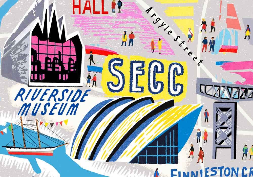
Illustrated Street-plan Maps


Turning city maps into lively portraits is my specialty! With my unique illustration approach and eye for detail, I craft maps for urban exploration with a difference. Using locally inspired lettering and illustrations, I capture the feel of a place, creating a snapshot of its character, helping clients connect with their audiences.
Immersive Map Illustration
Embark on a journey of imagination and emotional connection! These maps present beautiful landscapes for viewers to explore; intriguing and sometimes aspirational.
Drawing inspiration from each locale, I weave visual elements and lettering styles to craft pieces that evoke an authentic sense of place.
Map-reading becomes an exciting journey where audiences can discover your brand for themselves.